
Topografische kaart Intibucá
Interactieve kaart
Klik op de kaart om de hoogte weer te geven.
Over deze kaart
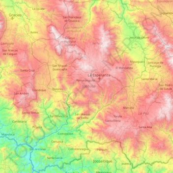
Naam: Topografische kaart Intibucá, hoogte, reliëf.
Locatie: Intibucá, Honduras (13.84856 -88.51109 14.65781 -87.84765)
Gemiddelde hoogte: 1.151 m
Minimale hoogte: 54 m
Maximale hoogte: 2.369 m
Andere topografische kaarten
Klik op een kaart om zijn topografie, zijn hoogte en zijn reliëf te bekijken.
Yamaranguila
Honduras > Intibucá > Yamaranguila
Yamaranguila, Intibucá, Honduras
Gemiddelde hoogte: 1.753 m
Cerro El Pelón
Honduras > Intibucá > La Esperanza
Cerro El Pelón, La Esperanza, Intibucá, Honduras
Gemiddelde hoogte: 1.913 m
La Esperanza
Honduras > Intibucá > La Esperanza
La Esperanza, Intibucá, Honduras
Gemiddelde hoogte: 1.534 m
Jesús de Otoro
Honduras > Intibucá > Jesús de Otoro
Jesús de Otoro, Intibucá, Honduras
Gemiddelde hoogte: 741 m
Río Guarajambala
Honduras > Intibucá > La Esperanza
Río Guarajambala, La Esperanza, Intibucá, Honduras
Gemiddelde hoogte: 489 m