
Topografische kaart Bluefield
Interactieve kaart
Klik op de kaart om de hoogte weer te geven.
Over deze kaart
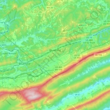
Naam: Topografische kaart Bluefield, hoogte, reliëf.
Gemiddelde hoogte: 819 m
Minimale hoogte: 630 m
Maximale hoogte: 1.248 m
Bluefield is a mountain city with a warm-summer humid continental climate (Dfb) bordering on subtropical highland climate or temperate oceanic climate (Cfb), due to its elevation. It is characterized by moderately cold, snowy winters and pleasantly warm to hot summers. The normal monthly mean daily temperature ranges from 31.9 °F (−0.1 °C) in January to 70.3 °F (21.3 °C) in July; on average, there are only 2.5 days with a maximum of at least 90 °F (32 °C) or greater maxima, 1.3 days of minima at or below 0 °F (−18 °C), and 23 days where the maximum does not rise above freezing. The hottest temperature ever recorded in the city was 99 °F (37 °C), set on July 28, 1952, and August 9, 1957, with the coldest temperature at −25 °F (−32 °C), set on December 30, 1917.
Andere topografische kaarten
Klik op een kaart om zijn topografie, zijn hoogte en zijn reliëf te bekijken.
Dunns
United States > West Virginia > Mercer County > Dunns
Dunns, Mercer County, West Virginia, United States
Gemiddelde hoogte: 675 m