
Topografische kaart Montrose
Interactieve kaart
Klik op de kaart om de hoogte weer te geven.
Over deze kaart
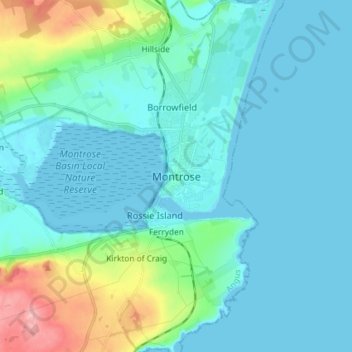
Naam: Topografische kaart Montrose, hoogte, reliëf.
Locatie: Montrose, Angus, Scotland, DD10 8QW, United Kingdom (56.67143 -2.50815 56.75143 -2.42815)
Gemiddelde hoogte: 22 m
Minimale hoogte: -2 m
Maximale hoogte: 135 m
Montrose occupies a position on the North Bank of Montrose Basin at the mouth of the River South Esk on the East Coast of Scotland, 11 miles (18 km) NNE of Arbroath, 19 miles (31 km) SW of Stonehaven, and 7.2 miles (12 km) ESE of Brechin. The town lies 62.2 miles (100 km) NNE of Edinburgh, and 373.2 miles (601 km) NNW of London. The built-up area occupies a roughly rectangular shape 2 miles (3 km) long by 0.75 miles (1 km) wide, aligned in a north–south orientation. The land is relatively flat, rising gradually to around 15m elevation to the North of the town.
Andere topografische kaarten
Klik op een kaart om zijn topografie, zijn hoogte en zijn reliëf te bekijken.
Brechin
United Kingdom > Scotland > Angus
Brechin, Angus, Scotland, DD9 6ET, United Kingdom
Gemiddelde hoogte: 71 m
Bridgefoot
United Kingdom > Scotland > Angus
Bridgefoot, Angus, Scotland, DD3 0TA, United Kingdom
Gemiddelde hoogte: 125 m
Eassie
United Kingdom > Scotland > Angus
Eassie, Angus, Scotland, DD8 1SG, United Kingdom
Gemiddelde hoogte: 73 m
Fern
United Kingdom > Scotland > Angus
Fern, Angus, Scotland, DD8 3QW, United Kingdom
Gemiddelde hoogte: 156 m
Padanaram
United Kingdom > Scotland > Angus > Padanaram
Padanaram, Angus, Scotland, DD8 1PT, United Kingdom
Gemiddelde hoogte: 68 m