
Topografische kaart Drummore
Interactieve kaart
Klik op de kaart om de hoogte weer te geven.
Over deze kaart
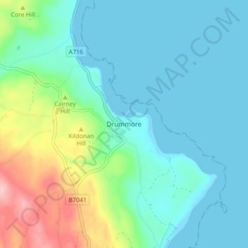
Naam: Topografische kaart Drummore, hoogte, reliëf.
Gemiddelde hoogte: 36 m
Minimale hoogte: 0 m
Maximale hoogte: 161 m
Andere topografische kaarten
Klik op een kaart om zijn topografie, zijn hoogte en zijn reliëf te bekijken.
Sanquhar
United Kingdom > Scotland > Dumfries and Galloway
Sanquhar, Dumfries and Galloway, Scotland, DG4 6DJ, United Kingdom
Gemiddelde hoogte: 243 m
Gillesbie
United Kingdom > Scotland > Dumfries and Galloway > Boreland
Gillesbie, Boreland, Dumfries and Galloway, Scotland, DG11 2LF, United Kingdom
Gemiddelde hoogte: 195 m
Holywood
United Kingdom > Scotland > Dumfries and Galloway
Holywood, Dumfries and Galloway, Scotland, DG2 0RE, United Kingdom
Gemiddelde hoogte: 26 m
Lockerbie
United Kingdom > Scotland > Dumfries and Galloway
Lockerbie, Dumfries and Galloway, Scotland, DG11 2EU, United Kingdom
Gemiddelde hoogte: 96 m
Ley Hill
United Kingdom > Scotland > Dumfries and Galloway
Ley Hill, Dumfries and Galloway, Scotland, DG11 3HG, United Kingdom
Gemiddelde hoogte: 214 m
Cairnryan
United Kingdom > Scotland > Dumfries and Galloway > Cairnryan
Cairnryan, Dumfries and Galloway, Scotland, DG9 8RB, United Kingdom
Gemiddelde hoogte: 64 m