
Topografische kaart Bentonville
Interactieve kaart
Klik op de kaart om de hoogte weer te geven.
Over deze kaart
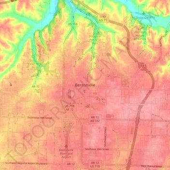
Naam: Topografische kaart Bentonville, hoogte, reliëf.
Locatie: Bentonville, Benton County, Arkansas, 72712, United States (36.33285 -94.24882 36.41285 -94.16882)
Gemiddelde hoogte: 383 m
Minimale hoogte: 319 m
Maximale hoogte: 407 m
Bentonville lies in the humid subtropical climate zone (Köppen Cfa) with influence from the humid continental climate type. Bentonville experiences all four seasons and does receive cold air masses from the north, however some of the Arctic masses are blocked by the higher elevations of the Ozarks. July is the hottest month of the year, with an average high of 89 °F (32 °C) and an average low of 66 °F (19 °C). Temperatures above 90 °F (32.2 °C) are common, with a high of 100 °F (37.8 °C) occurring about once per year on average. January is the coldest month with an average high of 46 °F (8 °C) and an average low of 24 °F (−4 °C). The city's highest temperature was 114 °F (45.6 °C), recorded in 1954. The lowest temperature recorded was −16 °F (−26.7 °C), in 1996.