
Topografische kaart Aldenham
Klik op de kaart om de hoogte weer te geven.
Over deze kaart
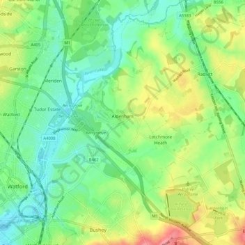
Naam: Topografische kaart Aldenham, hoogte, reliëf.
Gemiddelde hoogte: 82 m
Minimale hoogte: 52 m
Maximale hoogte: 136 m
Andere topografische kaarten
Klik op een kaart om zijn topografie, zijn hoogte en zijn reliëf te bekijken.
Well End
United Kingdom > England > Hertfordshire > Hertsmere > Borehamwood > Shenley
Gemiddelde hoogte: 108 m
Bushey
United Kingdom > England > Hertfordshire > Hertsmere
Bushey is a town in the Hertsmere borough of Hertfordshire in the East of England. It had a population of 25,328 in the 2011 census, rising to 28,416 in the 2021 census, an increase of 12.19%. This makes Bushey the second most populated town in Hertsmere. Bushey Heath is a large neighbourhood south east of…
Gemiddelde hoogte: 88 m
Bentley Heath
United Kingdom > England > Hertfordshire > Hertsmere > Potters Bar
Gemiddelde hoogte: 105 m
Elstree
United Kingdom > England > Hertfordshire > Hertsmere
In 1723, topographer John Norden noted in his book Speculum Britanniae, that in the county of Hartfordshire [sic] was one "Elstre or Eglestre". In an earlier edition, he writes.
Gemiddelde hoogte: 105 m
Merry Hill
United Kingdom > England > Hertfordshire > Hertsmere > Bushey Heath > Merry Hill
Gemiddelde hoogte: 98 m
Bushey
United Kingdom > England > Hertfordshire > Hertsmere
Bushey is a town in the Hertsmere borough of Hertfordshire in the East of England. It had a population of 25,328 in the 2011 census, rising to 28,416 in the 2021 census, an increase of 12.19%. This makes Bushey the second most populated town in Hertsmere. Bushey Heath is a large neighbourhood south east of…
Gemiddelde hoogte: 88 m
Patchetts Green
United Kingdom > England > Hertfordshire > Hertsmere > Aldenham
Gemiddelde hoogte: 83 m
Elstree
United Kingdom > England > Hertfordshire > Hertsmere
In 1723, topographer John Norden noted in his book Speculum Britanniae, that in the county of Hartfordshire [sic] was one "Elstre or Eglestre". In an earlier edition, he writes.
Gemiddelde hoogte: 105 m