
Topografische kaart Bristol
Interactieve kaart
Klik op de kaart om de hoogte weer te geven.
Over deze kaart
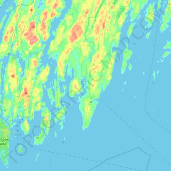
Naam: Topografische kaart Bristol, hoogte, reliëf.
Locatie: Bristol, Lincoln County, Maine, United States (43.77816 -69.54712 44.00874 -69.35277)
Gemiddelde hoogte: 13 m
Minimale hoogte: -2 m
Maximale hoogte: 96 m
Andere topografische kaarten
Klik op een kaart om zijn topografie, zijn hoogte en zijn reliëf te bekijken.
Hardy Island
United States > Maine > Lincoln County
Hardy Island, Lincoln County, Maine, United States
Gemiddelde hoogte: 31 m
Boothbay Harbor
United States > Maine > Lincoln County
Boothbay Harbor, Lincoln County, Maine, United States
Gemiddelde hoogte: 14 m