
Topografische kaart Ursa
Interactieve kaart
Klik op de kaart om de hoogte weer te geven.
Over deze kaart
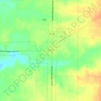
Naam: Topografische kaart Ursa, hoogte, reliëf.
Locatie: Ursa, Adams County, Illinois, United States (40.05991 -91.39515 40.08917 -91.36188)
Gemiddelde hoogte: 185 m
Minimale hoogte: 165 m
Maximale hoogte: 202 m
Andere topografische kaarten
Klik op een kaart om zijn topografie, zijn hoogte en zijn reliëf te bekijken.
Northridge
United States > Illinois > Adams County > Quincy
Northridge, Quincy, Adams County, Illinois, 62301, United States
Gemiddelde hoogte: 176 m
McDonald Island
United States > Illinois > Adams County
McDonald Island, Adams County, Illinois, United States
Gemiddelde hoogte: 142 m
Plainville
United States > Illinois > Adams County
Plainville, Adams County, Illinois, United States
Gemiddelde hoogte: 207 m
Quincy
United States > Illinois > Adams County
Quincy, Adams County, Illinois, United States
Gemiddelde hoogte: 169 m
Payson
United States > Illinois > Adams County
Payson, Adams County, Illinois, United States
Gemiddelde hoogte: 219 m
Quincy
United States > Illinois > Adams County > Quincy
Quincy, Adams County, Illinois, 62301, United States
Gemiddelde hoogte: 181 m
Mendon
United States > Illinois > Adams County
Mendon, Adams County, Illinois, United States
Gemiddelde hoogte: 223 m