
Topografische kaart Nadarzyn
Interactieve kaart
Klik op de kaart om de hoogte weer te geven.
Over deze kaart
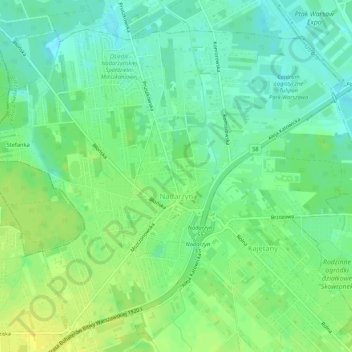
Naam: Topografische kaart Nadarzyn, hoogte, reliëf.
Gemiddelde hoogte: 112 m
Minimale hoogte: 102 m
Maximale hoogte: 124 m
Andere topografische kaarten
Klik op een kaart om zijn topografie, zijn hoogte en zijn reliëf te bekijken.
Stara Wieś
Poland > Masovian Voivodeship > Pruszków County
Stara Wieś, gmina Nadarzyn, Pruszków County, Masovian Voivodeship, Poland
Gemiddelde hoogte: 121 m
Rybie
Poland > Masovian Voivodeship > Pruszków County > Rybie
Rybie, gmina Raszyn, Pruszków County, Masovian Voivodeship, Poland
Gemiddelde hoogte: 106 m
Pruszków
Poland > Masovian Voivodeship > Pruszków County > Pruszków
Pruszków, gmina Ożarów Mazowiecki, Pruszków County, Masovian Voivodeship, Poland
Gemiddelde hoogte: 99 m