
Topografische kaart Ropczyce
Interactieve kaart
Klik op de kaart om de hoogte weer te geven.
Over deze kaart
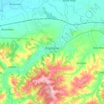
Naam: Topografische kaart Ropczyce, hoogte, reliëf.
Gemiddelde hoogte: 250 m
Minimale hoogte: 190 m
Maximale hoogte: 382 m
Ropczyce is located east of Kraków and west of Rzeszów. The coordinates for Ropczyce: Latitude 50°0500' and Longitude 21°6167. In DMS or Degree, Minutes, & Seconds; Latitude 50°2'60N and Longitude is 21°37'0E. Its elevation is 240 metres (787 feet) above sea level. The time zone for Poland is UTC+1.