
Topografische kaart Marsh Pass
Interactieve kaart
Klik op de kaart om de hoogte weer te geven.
Over deze kaart
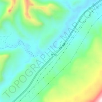
Naam: Topografische kaart Marsh Pass, hoogte, reliëf.
Gemiddelde hoogte: 1.961 m
Minimale hoogte: 1.833 m
Maximale hoogte: 2.320 m
Marsh Pass, also known as La Puerta Limita, "The Border Gate", is a gap in Navajo County, Arizona. It lies at an elevation of 6,102 feet (1,860 meters) along Laguña Creek. The name of Marsh Pass is thought to come from its location along a chain of swamps and lakes in the pass, that have since been drained by a deep arroyo.