
Topografische kaart Jakes Landing
Interactieve kaart
Klik op de kaart om de hoogte weer te geven.
Over deze kaart
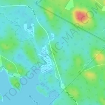
Naam: Topografische kaart Jakes Landing, hoogte, reliëf.
Gemiddelde hoogte: 102 m
Minimale hoogte: 87 m
Maximale hoogte: 151 m
Andere topografische kaarten
Klik op een kaart om zijn topografie, zijn hoogte en zijn reliëf te bekijken.
Kejimkujik National Park and National Historic Site of Canada
Canada > Nova Scotia > Municipality of the County of Annapolis > Kejimkujik National Park of Canada
Kejimkujik National Park and National Historic Site of Canada, Kejimkujik National Park of Canada, Municipality of the County of Annapolis, Annapolis County, Nova Scotia, B0T 1N0, Canada
Gemiddelde hoogte: 121 m