
Topografische kaart Celestún
Interactieve kaart
Klik op de kaart om de hoogte weer te geven.
Over deze kaart
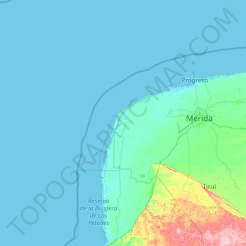
Naam: Topografische kaart Celestún, hoogte, reliëf.
Locatie: Celestún, Yucatán, 97367, Mexico (20.73421 -92.30816 21.10919 -90.12385)
Gemiddelde hoogte: 11 m
Minimale hoogte: -4 m
Maximale hoogte: 194 m
Andere topografische kaarten
Klik op een kaart om zijn topografie, zijn hoogte en zijn reliëf te bekijken.
Chichen-Itza
Mexico > Yucatán > Tinum > San Felipe Nuevo
Chichen-Itza, Group of the Thousand Columns, San Felipe Nuevo, Tinum, Yucatán, 97751, Mexico
Gemiddelde hoogte: 27 m
Valladolid
Mexico > Yucatán > Valladolid > Valladolid
Valladolid, Yucatán, 97780, Mexico
Gemiddelde hoogte: 23 m
San Antonio Tzacalá
Mexico > Yucatán > Mérida > San Antonio Tzacalá
San Antonio Tzacalá, Mérida, Yucatán, Mexico
Gemiddelde hoogte: 12 m
Chicxulub Puerto
Mexico > Yucatán > Chicxulub Puerto
Chicxulub Puerto, Progreso, Yucatán, Mexico
Gemiddelde hoogte: 0 m
Chactún (San José Chactún)
Mexico > Yucatán > Maxcanú > Chactún (San José Chactún)
Chactún (San José Chactún), Maxcanú, Yucatán, Mexico
Gemiddelde hoogte: 26 m
Uxmal
Mexico > Yucatán > San Isidro
Uxmal, San Isidro, Santa Elena, Yucatán, Mexico
Gemiddelde hoogte: 51 m
San Isidro
Mexico > Yucatán > Tizimín > San Isidro
San Isidro, Tizimín, Yucatán, Mexico
Gemiddelde hoogte: 11 m
Celtún
Mexico > Yucatán > Chichimilá > Celtún
Celtún, Chichimilá, Yucatán, Mexico
Gemiddelde hoogte: 23 m
San Pedro Dzulá
Mexico > Yucatán > San Pedro Dzulá
San Pedro Dzulá, Cacalchén, Yucatán, Mexico
Gemiddelde hoogte: 11 m
San Felipe Nuevo
Mexico > Yucatán > Tinum > San Felipe Nuevo
San Felipe Nuevo, Tinum, Yucatán, 97751, Mexico
Gemiddelde hoogte: 27 m
San Franscisco
Mexico > Yucatán > San Franscisco
San Franscisco, Tizimín, Yucatán, Mexico
Gemiddelde hoogte: 12 m