
Topografische kaart Langstone
Klik op de kaart om de hoogte weer te geven.
Over deze kaart
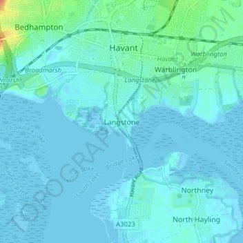
Naam: Topografische kaart Langstone, hoogte, reliëf.
Locatie: Langstone, Havant, Hampshire, England, PO9 1RF, United Kingdom (50.81974 -1.00261 50.85974 -0.96261)
Gemiddelde hoogte: 5 m
Minimale hoogte: -4 m
Maximale hoogte: 37 m
Andere topografische kaarten
Klik op een kaart om zijn topografie, zijn hoogte en zijn reliëf te bekijken.
Hayling Island
United Kingdom > England > Hampshire > Havant > North Hayling
An Iron Age shrine in the north of Hayling Island was later developed into a Roman temple in the 1st century BC and was first recorded in Richard Scott's Topographical and Historical Account of Hayling Island (1826). The site was dug between 1897 and 1907 and again from 1976 to 1978. The remains are now buried…
Gemiddelde hoogte: 1 m
Hayling Island
United Kingdom > England > Hampshire > Havant > Fleet
An Iron Age shrine in the north of Hayling Island was later developed into a Roman temple in the 1st century BC and was first recorded in Richard Scott's Topographical and Historical Account of Hayling Island (1826). The site was dug between 1897 and 1907 and again from 1976 to 1978. The remains are now buried…
Gemiddelde hoogte: 1 m