
Topografische kaart Bisley
Klik op de kaart om de hoogte weer te geven.
Over deze kaart
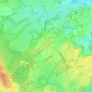
Naam: Topografische kaart Bisley, hoogte, reliëf.
Locatie: Bisley, Surrey Heath, Surrey, England, United Kingdom (51.31188 -0.65901 51.33594 -0.61339)
Gemiddelde hoogte: 46 m
Minimale hoogte: 27 m
Maximale hoogte: 70 m
Andere topografische kaarten
Klik op een kaart om zijn topografie, zijn hoogte en zijn reliëf te bekijken.
Camberley
United Kingdom > England > Surrey > Surrey Heath
The Staff College, to the north of Camberley town centre, is part of the Joint Services Command and Staff College, which provides training and education for established officers in the British Armed Forces and civil servants in the Ministry of Defence. The institution has its origins in the Royal Military…
Gemiddelde hoogte: 88 m
Bagshot Park Mansion
United Kingdom > England > Surrey > Surrey Heath > Bagshot
Gemiddelde hoogte: 76 m
Frimley Lodge Park
United Kingdom > England > Surrey > Surrey Heath > Frimley Green
Gemiddelde hoogte: 80 m
Kalima Caravan Site
United Kingdom > England > Surrey > Surrey Heath > Chobham
Gemiddelde hoogte: 28 m
Camberley
United Kingdom > England > Surrey > Surrey Heath
The Staff College, to the north of Camberley town centre, is part of the Joint Services Command and Staff College, which provides training and education for established officers in the British Armed Forces and civil servants in the Ministry of Defence. The institution has its origins in the Royal Military…
Gemiddelde hoogte: 88 m