
Doe een donatie
Rust jezelf uit voor je volgende avontuur:
Als Amazon-partner verdient deze site een commissie op in aanmerking komende aankopen, zonder extra kosten voor jou.
Topografische kaart Berwyn
Klik op de kaart om de hoogte weer te geven.
Doe een donatie
Rust jezelf uit voor je volgende avontuur:
Als Amazon-partner verdient deze site een commissie op in aanmerking komende aankopen, zonder extra kosten voor jou.
Berwyn
According to the 2021 census gazetteer files, Berwyn has a total area of 3.90 square miles (10.10 km2), all land. Bordering cities include Oak Park to the north, Cicero to the east, Stickney to the south, Lyons, Riverside, North Riverside, and Forest Park to the west. Geologically, Berwyn is predominately composed of Glacial Lake Bottom from the Wisconsin Glacial Episode, the most recent glacial period. A beach ridge of sand and gravel, made during one of the stages of Lake Chicago, is also present in the city. This is most easily identified as Riverside Drive. The elevation change due to the ridge is clearly seen on the 2800 block of Maple Ave. Prior to the settlement of Berwyn, the land was grassy marshland. The body of water that connected the South Branch of the Chicago River to the Des Plaines River was a shallow waterway or a muddy slough (depending on the season) known as Mud Lake. Mud Lake extended nearly to the southern border of today's Berwyn, and the southern end of Berwyn flooded regularly during heavy rains in its early years.
Doe een donatie
Rust jezelf uit voor je volgende avontuur:
Als Amazon-partner verdient deze site een commissie op in aanmerking komende aankopen, zonder extra kosten voor jou.
Over deze kaart
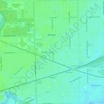
Naam: Topografische kaart Berwyn, hoogte, reliëf.
Locatie: Berwyn, Cook County, Illinois, United States (41.82115 -87.80422 41.86540 -87.77778)
Gemiddelde hoogte: 188 m
Minimale hoogte: 183 m
Maximale hoogte: 193 m
Doe een donatie
Rust jezelf uit voor je volgende avontuur:
Als Amazon-partner verdient deze site een commissie op in aanmerking komende aankopen, zonder extra kosten voor jou.
Andere topografische kaarten
Klik op een kaart om zijn topografie, zijn hoogte en zijn reliëf te bekijken.
Doe een donatie
Rust jezelf uit voor je volgende avontuur:
Als Amazon-partner verdient deze site een commissie op in aanmerking komende aankopen, zonder extra kosten voor jou.
Doe een donatie
Rust jezelf uit voor je volgende avontuur:
Als Amazon-partner verdient deze site een commissie op in aanmerking komende aankopen, zonder extra kosten voor jou.
Doe een donatie
Rust jezelf uit voor je volgende avontuur:
Als Amazon-partner verdient deze site een commissie op in aanmerking komende aankopen, zonder extra kosten voor jou.
Doe een donatie
Rust jezelf uit voor je volgende avontuur:
Als Amazon-partner verdient deze site een commissie op in aanmerking komende aankopen, zonder extra kosten voor jou.
Doe een donatie
Rust jezelf uit voor je volgende avontuur:
Als Amazon-partner verdient deze site een commissie op in aanmerking komende aankopen, zonder extra kosten voor jou.
Chicago, North Shore & Milwaukee
United States > Illinois > Cook County > Northbrook > Williamsburg Square
Gemiddelde hoogte: 198 m
Doe een donatie
Rust jezelf uit voor je volgende avontuur:
Als Amazon-partner verdient deze site een commissie op in aanmerking komende aankopen, zonder extra kosten voor jou.
Elmwood Park
United States > Illinois > Cook County > Elmwood Park > Elmwood Park
Gemiddelde hoogte: 194 m
Doe een donatie
Rust jezelf uit voor je volgende avontuur:
Als Amazon-partner verdient deze site een commissie op in aanmerking komende aankopen, zonder extra kosten voor jou.
West Branch Du Page River
United States > Illinois > Cook County > Schaumburg
Gemiddelde hoogte: 249 m