
Topografische kaart Balsthal
Interactieve kaart
Klik op de kaart om de hoogte weer te geven.
Over deze kaart
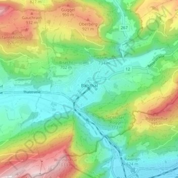
Naam: Topografische kaart Balsthal, hoogte, reliëf.
Locatie: Balsthal, Bezirk Thal, Amtei Thal-Gäu, Soleure, 4710, Suisse (47.28901 7.67040 47.33697 7.74540)
Gemiddelde hoogte: 680 m
Minimale hoogte: 453 m
Maximale hoogte: 1.112 m