
Topografische kaart Sussex
Interactieve kaart
Klik op de kaart om de hoogte weer te geven.
Over deze kaart
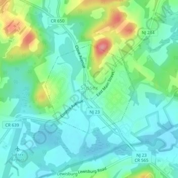
Naam: Topografische kaart Sussex, hoogte, reliëf.
Locatie: Sussex, Sussex County, New Jersey, 10985, United States (41.20284 -74.61655 41.21633 -74.59857)
Gemiddelde hoogte: 142 m
Minimale hoogte: 116 m
Maximale hoogte: 215 m
Due to its inland location and elevation, Sussex has a climate much cooler than most of the state, classified as humid continental (Köppen Dfa), with cold, moderately snowy winters, and very warm, humid summers. It is part of USDA Plant Hardiness Zone 6. The monthly daily average temperature ranges from 25.8 °F (−3.4 °C) in January to 71.8 °F (22.1 °C) in July. Temperatures reach 90 °F (32 °C) on 13.4 days and fall to 0 °F (−18 °C) on 5.2 nights annually. Snowfall averages 38.7 inches (98 cm) per season, although this usually varies widely from year to year. Extremes in the temperature range from −29 °F (−34 °C) on January 21, 1994 up to 106 °F (41 °C) on July 10, 1936.