
Topografische kaart Coupar Angus
Interactieve kaart
Klik op de kaart om de hoogte weer te geven.
Over deze kaart
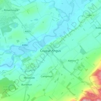
Naam: Topografische kaart Coupar Angus, hoogte, reliëf.
Gemiddelde hoogte: 70 m
Minimale hoogte: 30 m
Maximale hoogte: 298 m
Andere topografische kaarten
Klik op een kaart om zijn topografie, zijn hoogte en zijn reliëf te bekijken.
Blacklunans
United Kingdom > Scotland > Perth and Kinross
Blacklunans, Perth and Kinross, Scotland, PH10 7LL, United Kingdom
Gemiddelde hoogte: 357 m
Perth
United Kingdom > Scotland > Perth and Kinross
Perth, Perth and Kinross, Scotland, PH1 5SU, United Kingdom
Gemiddelde hoogte: 131 m
Crieff
United Kingdom > Scotland > Perth and Kinross
Crieff, Perth and Kinross, Scotland, PH7 3BS, United Kingdom
Gemiddelde hoogte: 115 m
Forgandenny
United Kingdom > Scotland > Perth and Kinross
Forgandenny, Perth and Kinross, Scotland, PH2 9EQ, United Kingdom
Gemiddelde hoogte: 53 m
Blairgowrie and Rattray
United Kingdom > Scotland > Perth and Kinross > Blairgowrie and Rattray
Blairgowrie and Rattray, Perth and Kinross, Scotland, PH10 6AB, United Kingdom
Gemiddelde hoogte: 121 m
Kindallachan
United Kingdom > Scotland > Perth and Kinross
Kindallachan, Perth and Kinross, Scotland, PH9 0NW, United Kingdom
Gemiddelde hoogte: 162 m