
Topografische kaart Heritage Acres
Interactieve kaart
Klik op de kaart om de hoogte weer te geven.
Over deze kaart
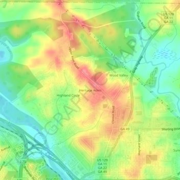
Naam: Topografische kaart Heritage Acres, hoogte, reliëf.
Gemiddelde hoogte: 119 m
Minimale hoogte: 84 m
Maximale hoogte: 158 m
Andere topografische kaarten
Klik op een kaart om zijn topografie, zijn hoogte en zijn reliëf te bekijken.
Sofkee
United States > Georgia > Bibb County > Macon
Sofkee, Macon, Bibb County, Georgia, 31297, United States
Gemiddelde hoogte: 110 m
Avondale
United States > Georgia > Bibb County > Macon
Avondale, Macon, Bibb County, Georgia, 31297, United States
Gemiddelde hoogte: 98 m
Wood Valley
United States > Georgia > Bibb County > Macon
Wood Valley, Macon, Bibb County, Georgia, 31211, United States
Gemiddelde hoogte: 120 m
Christophers Cove
United States > Georgia > Bibb County > Macon
Christophers Cove, Macon, Bibb County, Georgia, 31220, United States
Gemiddelde hoogte: 130 m
Lake Arrowhead
United States > Georgia > Bibb County > Macon
Lake Arrowhead, Macon, Bibb County, Georgia, 31217, United States
Gemiddelde hoogte: 137 m
Lizella
United States > Georgia > Bibb County > Macon > Lizella
Lizella, Macon, Bibb County, Georgia, 31052, United States
Gemiddelde hoogte: 146 m
Ocmulgee Mounds National Historical Park
United States > Georgia > Bibb County > Macon
Ocmulgee Mounds National Historical Park, Short Circle, Macon, Bibb County, Georgia, 31201-1662, United States
Gemiddelde hoogte: 96 m
Idlewood
United States > Georgia > Bibb County > Macon
Idlewood, Macon, Bibb County, Georgia, 31210, United States
Gemiddelde hoogte: 132 m