
Topografische kaart Lawrence
Interactieve kaart
Klik op de kaart om de hoogte weer te geven.
Over deze kaart
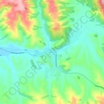
Naam: Topografische kaart Lawrence, hoogte, reliëf.
Locatie: Lawrence, Clutha District, Otago, 9532, New Zealand (-45.93293 169.66700 -45.89293 169.70700)
Gemiddelde hoogte: 163 m
Minimale hoogte: 93 m
Maximale hoogte: 307 m
Andere topografische kaarten
Klik op een kaart om zijn topografie, zijn hoogte en zijn reliëf te bekijken.
Waitahuna Hill
New Zealand > Otago > Clutha District
Waitahuna Hill, Clutha District, Otago, New Zealand
Gemiddelde hoogte: 537 m
Beaumont
New Zealand > Otago > Clutha District
Beaumont, Clutha District, Otago, New Zealand
Gemiddelde hoogte: 122 m
Waihola Hill
New Zealand > Otago > Clutha District
Waihola Hill, Clutha District, Otago, 9243, New Zealand
Gemiddelde hoogte: 55 m
Balclutha
New Zealand > Otago > Clutha District
Balclutha, Clutha District, Otago, 9230, New Zealand
Gemiddelde hoogte: 40 m
Owaka
New Zealand > Otago > Clutha District
Owaka, Clutha District, Otago, 9535, New Zealand
Gemiddelde hoogte: 27 m
Clinton
New Zealand > Otago > Clutha District
Clinton, Clutha District, Otago, 9534, New Zealand
Gemiddelde hoogte: 153 m
Tokoiti
New Zealand > Otago > Clutha District > Milton > Tokoiti
Tokoiti, Milton, Clutha District, Otago, 9220, New Zealand
Gemiddelde hoogte: 50 m
Taieri Mouth
New Zealand > Otago > Clutha District
Taieri Mouth, Clutha District, Otago, New Zealand
Gemiddelde hoogte: 46 m
Kapiti
New Zealand > Otago > Clutha District
Kapiti, Clutha District, Otago, 9291, New Zealand
Gemiddelde hoogte: 92 m