
Topografische kaart Hinnom
Interactieve kaart
Klik op de kaart om de hoogte weer te geven.
Over deze kaart
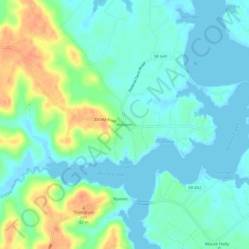
Naam: Topografische kaart Hinnom, hoogte, reliëf.
Locatie: Hinnom, Westmoreland County, Virginia, 22520, United States (38.09041 -76.75690 38.13041 -76.71690)
Gemiddelde hoogte: 13 m
Minimale hoogte: -2 m
Maximale hoogte: 46 m
Andere topografische kaarten
Klik op een kaart om zijn topografie, zijn hoogte en zijn reliëf te bekijken.
Colonial Beach
United States > Virginia > Westmoreland County
Colonial Beach, Westmoreland County, Virginia, United States
Gemiddelde hoogte: 2 m
Latanes
United States > Virginia > Westmoreland County
Latanes, Westmoreland County, Virginia, 22443, United States
Gemiddelde hoogte: 15 m
Latanes Pond
United States > Virginia > Westmoreland County > Laurel Grove
Latanes Pond, Laurel Grove, Westmoreland County, Virginia, United States
Gemiddelde hoogte: 9 m
Leedstown
United States > Virginia > Westmoreland County
Leedstown, Westmoreland County, Virginia, United States
Gemiddelde hoogte: 6 m