
Topografische kaart Spartanburg County
Interactieve kaart
Klik op de kaart om de hoogte weer te geven.
Over deze kaart
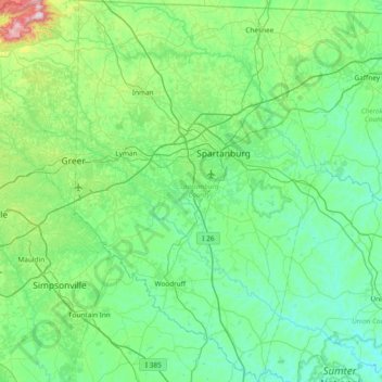
Naam: Topografische kaart Spartanburg County, hoogte, reliëf.
Locatie: Spartanburg County, South Carolina, Verenigde Staten (34.58016 -82.22661 35.19624 -81.71409)
Gemiddelde hoogte: 239 m
Minimale hoogte: 103 m
Maximale hoogte: 974 m
Andere topografische kaarten
Klik op een kaart om zijn topografie, zijn hoogte en zijn reliëf te bekijken.
Palmetto Bluff
Verenigde Staten > South Carolina > Beaufort County > Bluffton
Palmetto Bluff, Bluffton, Beaufort County, South Carolina, 29910, Verenigde Staten
Gemiddelde hoogte: 5 m
Kiawah Island
Verenigde Staten > South Carolina > Charleston County > Kiawah Island
Kiawah Island, Charleston County, South Carolina, Verenigde Staten
Gemiddelde hoogte: 2 m
Bird Mountain
Verenigde Staten > South Carolina > Spartanburg County
Bird Mountain, Spartanburg County, South Carolina, 29256, Verenigde Staten
Gemiddelde hoogte: 344 m