
Topografische kaart Bathgate
Interactieve kaart
Klik op de kaart om de hoogte weer te geven.
Over deze kaart
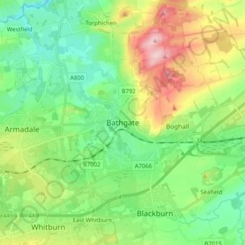
Naam: Topografische kaart Bathgate, hoogte, reliëf.
Locatie: Bathgate, West Lothian, Scotland, EH48 1PA, United Kingdom (55.86092 -3.68148 55.94092 -3.60148)
Gemiddelde hoogte: 167 m
Minimale hoogte: 97 m
Maximale hoogte: 311 m
In the 1846 book A Topographical Dictionary of Scotland, Samuel Lewis writes:
Andere topografische kaarten
Klik op een kaart om zijn topografie, zijn hoogte en zijn reliëf te bekijken.
Livingston
United Kingdom > Scotland > West Lothian
Livingston, West Lothian, Scotland, EH54 6HS, United Kingdom
Gemiddelde hoogte: 158 m