
Topografische kaart Lewiston
Interactieve kaart
Klik op de kaart om de hoogte weer te geven.
Lewiston
According to the U.S. Census Bureau, the city has a total area of 18.04 square miles (46.72 km2), of which 17.23 square miles (44.63 km2) is land and 0.81 square miles (2.10 km2) is water. Downtown Lewiston, at elevations between 740 feet (230 m) and 780 feet (240 m), is only slightly higher in elevation than the river, about 741 ft (226 m), which was thirty feet (9 m) lower prior to the completion of the Lower Granite Dam. Away from downtown the terrain gains elevation quickly, as the steep riverbank highway of U.S. 95 north of Lewiston ascends to 2,756 feet (840 m).
Over deze kaart
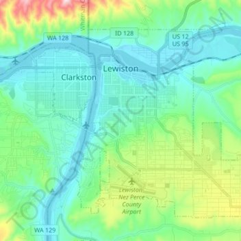
Naam: Topografische kaart Lewiston, hoogte, reliëf.
Locatie: Lewiston, Nez Perce County, Idaho, United States (46.36165 -117.04659 46.43711 -116.91126)
Gemiddelde hoogte: 334 m
Minimale hoogte: 219 m
Maximale hoogte: 758 m