
Topografische kaart Dallas
Interactieve kaart
Klik op de kaart om de hoogte weer te geven.
Over deze kaart
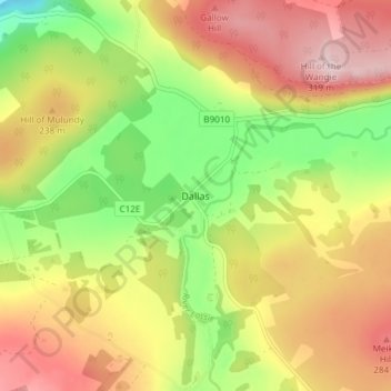
Naam: Topografische kaart Dallas, hoogte, reliëf.
Locatie: Dallas, Moray, Scotland, IV36 2SA, United Kingdom (57.53156 -3.48886 57.57156 -3.44886)
Gemiddelde hoogte: 205 m
Minimale hoogte: 79 m
Maximale hoogte: 326 m
Andere topografische kaarten
Klik op een kaart om zijn topografie, zijn hoogte en zijn reliëf te bekijken.
Glenlivet
United Kingdom > Scotland > Moray
Glenlivet, Moray, Scotland, AB37 9BT, United Kingdom
Gemiddelde hoogte: 280 m
Dufftown
United Kingdom > Scotland > Moray
Dufftown, Moray, Scotland, AB55 4AD, United Kingdom
Gemiddelde hoogte: 268 m
Spey Bay
United Kingdom > Scotland > Moray
Spey Bay, Moray, Scotland, IV32 7RR, United Kingdom
Gemiddelde hoogte: 5 m
Longmorn
United Kingdom > Scotland > Moray > Longmorn
Longmorn, Moray, Scotland, IV30 8SA, United Kingdom
Gemiddelde hoogte: 67 m
Ballindalloch
United Kingdom > Scotland > Moray > Ballindalloch
Ballindalloch, Moray, Scotland, AB37 9YF, United Kingdom
Gemiddelde hoogte: 233 m
Forres
United Kingdom > Scotland > Moray > Forres
Forres, Moray, Scotland, IV36 1NX, United Kingdom
Gemiddelde hoogte: 31 m
Kinloss
United Kingdom > Scotland > Moray
Kinloss, Moray, Scotland, IV36 3UT, United Kingdom
Gemiddelde hoogte: 10 m