
Topografische kaart Northwest Miramachi River
Interactieve kaart
Klik op de kaart om de hoogte weer te geven.
Over deze kaart
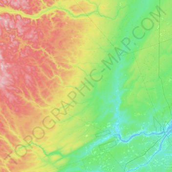
Naam: Topografische kaart Northwest Miramachi River, hoogte, reliëf.
Gemiddelde hoogte: 214 m
Minimale hoogte: -3 m
Maximale hoogte: 666 m
Andere topografische kaarten
Klik op een kaart om zijn topografie, zijn hoogte en zijn reliëf te bekijken.
Wayerton
Canada > New Brunswick > Northesk Parish
Wayerton, Northesk Parish, Northumberland County, New Brunswick, Canada
Gemiddelde hoogte: 46 m
Sevogle
Canada > New Brunswick > Northesk Parish
Sevogle, Northesk Parish, Northumberland County, New Brunswick, E9E 1R3, Canada
Gemiddelde hoogte: 46 m
Sunny Corner
Canada > New Brunswick > Northesk Parish
Sunny Corner, Northesk Parish, Northumberland County, New Brunswick, E9E 1J1, Canada
Gemiddelde hoogte: 28 m
Northesk
Canada > New Brunswick > Northesk Parish
Northesk, Northesk Parish, Northumberland County, New Brunswick, Canada
Gemiddelde hoogte: 402 m