
Topografische kaart Briar Lake
Interactieve kaart
Klik op de kaart om de hoogte weer te geven.
Over deze kaart
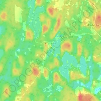
Naam: Topografische kaart Briar Lake, hoogte, reliëf.
Gemiddelde hoogte: 67 m
Minimale hoogte: 44 m
Maximale hoogte: 96 m
Andere topografische kaarten
Klik op een kaart om zijn topografie, zijn hoogte en zijn reliëf te bekijken.
Haines Lake
Canada > Nova Scotia > Digby County > North Range
Haines Lake, North Range, Digby Municipal District, Digby County, Nova Scotia, B0W 1H0, Canada
Gemiddelde hoogte: 104 m
Freeport
Canada > Nova Scotia > Digby County
Freeport, Digby Municipal District, Digby County, Nova Scotia, B0V 1B0, Canada
Gemiddelde hoogte: 7 m
Corberrie
Canada > Nova Scotia > Digby County
Corberrie, Clare Municipal District, Digby County, Nova Scotia, B0W 3M0, Canada
Gemiddelde hoogte: 75 m