
Topografische kaart Tabanan
Interactieve kaart
Klik op de kaart om de hoogte weer te geven.
Over deze kaart
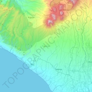
Naam: Topografische kaart Tabanan, hoogte, reliëf.
Locatie: Tabanan, Bali, Indonesia (-8.63601 114.91527 -8.24317 115.21733)
Gemiddelde hoogte: 450 m
Minimale hoogte: 0 m
Maximale hoogte: 2.235 m
Jatiluwih village in Penebel District, north of Tabanan, has paddy fields following the contours of terraced land against the background of spellbinding Mount Batukaru and Mount Agung use traditional Balinese irrigation known as subak, Bali's community-based water control management system. Lies at an altitude of 700 meters, the cool atmosphere of more original beautiful Jatiluwih is better than the most well-known Tegallalang which has plenty of cafes and souvenir shops. Two routes to Jatiluwih are Denpasar>Kediri>Tabanan>Penebel>Jatiluwih or Denpasar>Mengwi>Baturiti>Jatiluwih. Jatiluwih is one of the five rice terraces that describe the "Subak" water management system which has gain acknowledgment from UNESCO as part of the world's cultural heritage.
Andere topografische kaarten
Klik op een kaart om zijn topografie, zijn hoogte en zijn reliëf te bekijken.
Candidasa
Indonesia > Bali > Karangasem
Candidasa, Kecamatan Karangasem, Karangasem, Bali, 80851, Indonesia
Gemiddelde hoogte: 45 m
Kubutambahan
Kubutambahan, Buleleng, Bali, Lesser Sunda Islands, 81172, Indonesia
Gemiddelde hoogte: 33 m
Semarapura Kelod
Indonesia > Bali > Semarapura Kelod
Semarapura Kelod, Bali, Indonesia
Gemiddelde hoogte: 80 m
Dauh Puri Kangin
Indonesia > Bali > Denpasar > Dauh Puri Kangin
Dauh Puri Kangin, Denpasar Barat, Denpasar, Bali, 80232, Indonesia
Gemiddelde hoogte: 26 m