
Topografische kaart Jasidih
Interactieve kaart
Klik op de kaart om de hoogte weer te geven.
Over deze kaart
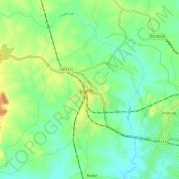
Naam: Topografische kaart Jasidih, hoogte, reliëf.
Locatie: Jasidih, Deoghar, Jharkhand, 814142, India (24.47425 86.60696 24.55425 86.68696)
Gemiddelde hoogte: 251 m
Minimale hoogte: 224 m
Maximale hoogte: 309 m
Jasidih is a Hill Station located at 20°N 89°E / 20°N 89°E / 20; 89. It has an average elevation of 260 metres (853 feet). Its nearby villages are Rohini, Kushmaha, Tabhaghat and others.