
Topografische kaart Warrior
Interactieve kaart
Klik op de kaart om de hoogte weer te geven.
Warrior
Warrior is in the Central time zone. The elevation at the center of town is 564 feet (172 m), though it ranges from over 620 feet (190 m) north of the center to less than 300 feet (91 m) along the Locust Fork of the Black Warrior River, which forms the southern boundary of the city.
Over deze kaart
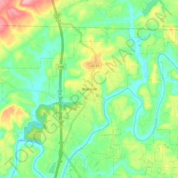
Naam: Topografische kaart Warrior, hoogte, reliëf.
Locatie: Warrior, Jefferson County, Alabama, 35180, United States (33.77427 -86.84944 33.85427 -86.76944)
Gemiddelde hoogte: 143 m
Minimale hoogte: 91 m
Maximale hoogte: 242 m