
Topografische kaart Cloudcroft
Interactieve kaart
Klik op de kaart om de hoogte weer te geven.
Over deze kaart
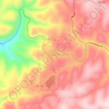
Naam: Topografische kaart Cloudcroft, hoogte, reliëf.
Locatie: Cloudcroft, Otero County, New Mexico, 88317, United States (32.93766 -105.76272 32.97766 -105.72272)
Gemiddelde hoogte: 2.636 m
Minimale hoogte: 2.352 m
Maximale hoogte: 2.776 m
Cloudcroft is a village in Otero County, New Mexico, United States, and is located within the Lincoln National Forest. The population was 674 at the 2010 census. Despite being located in an otherwise arid region, its high elevation (8,676 feet (2,644 m); one of the highest in the U.S.) allows for a mild summer that makes it a popular tourist attraction in west Texas and southern New Mexico. It was named by Fodor's in 2002 as the Number 3 "Most Overlooked and Underrated Destination Spot." Tourism remains the primary economic driver of the village.