
Topografische kaart St. Levan
Interactieve kaart
Klik op de kaart om de hoogte weer te geven.
Over deze kaart
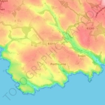
Naam: Topografische kaart St. Levan, hoogte, reliëf.
Locatie: St. Levan, Porthcurno, Cornwall, England, United Kingdom (50.03448 -5.69584 50.07059 -5.62763)
Gemiddelde hoogte: 57 m
Minimale hoogte: 0 m
Maximale hoogte: 118 m
Andere topografische kaarten
Klik op een kaart om zijn topografie, zijn hoogte en zijn reliëf te bekijken.
Porthcurno
United Kingdom > England > Cornwall > Porthcurno > St. Levan
Porthcurno, St. Levan, Porthcurno, Cornwall, England, United Kingdom
Gemiddelde hoogte: 39 m
Levans Wall
United Kingdom > England > Cornwall > Porthcurno > St. Levan
Levans Wall, St. Levan, Porthcurno, Cornwall, England, TR19 6JT, United Kingdom
Gemiddelde hoogte: 28 m