
Topografische kaart Missoula
Interactieve kaart
Klik op de kaart om de hoogte weer te geven.
Over deze kaart
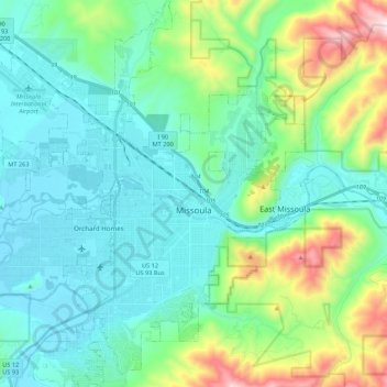
Naam: Topografische kaart Missoula, hoogte, reliëf.
Locatie: Missoula, Missoula County, Montana, United States (46.79154 -114.12729 46.94995 -113.89732)
Gemiddelde hoogte: 1.173 m
Minimale hoogte: 943 m
Maximale hoogte: 2.021 m
Missoula is located at the western edge of Montana, approximately 45 miles (70 km) from the Idaho border. The city is at an elevation of 3,209 feet (978 m) above sea level, with nearby Mount Sentinel and Mount Jumbo steeply rising to 5,158 feet (1,572 m) and 4,768 feet (1,453 m), respectively. According to the Census Bureau's 2015 figures, the city had a total area of 29.08 square miles (75.3 km2), of which 28.90 square miles (74.9 km2) were land and 0.184 square miles (0.48 km2) were covered by water.
Andere topografische kaarten
Klik op een kaart om zijn topografie, zijn hoogte en zijn reliëf te bekijken.
Frenchtown
United States > Montana > Missoula County > Frenchtown
Frenchtown, Missoula County, Montana, United States
Gemiddelde hoogte: 1.019 m
Seeley Lake
United States > Montana > Missoula County
Seeley Lake, Missoula County, Montana, United States
Gemiddelde hoogte: 1.348 m
Missoula
United States > Montana > Missoula County > Missoula
Missoula, Missoula County, Montana, 59807, United States
Gemiddelde hoogte: 1.354 m
De Smet
United States > Montana > Missoula County
De Smet, Missoula County, Montana, 59808, United States
Gemiddelde hoogte: 996 m
Condon
United States > Montana > Missoula County
Condon, Missoula County, Montana, 59826, United States
Gemiddelde hoogte: 1.146 m
Seeley Lake
United States > Montana > Missoula County
Seeley Lake, Missoula County, Montana, 59868, United States
Gemiddelde hoogte: 1.250 m
Clinton
United States > Montana > Missoula County
Clinton, Missoula County, Montana, United States
Gemiddelde hoogte: 1.180 m
Lolo
United States > Montana > Missoula County > Lolo
Lolo, Missoula County, Montana, United States
Gemiddelde hoogte: 1.077 m
Clearwater Lake
United States > Montana > Missoula County
Clearwater Lake, Missoula County, Montana, United States
Gemiddelde hoogte: 1.491 m
Lolo Hot Springs
United States > Montana > Missoula County > Lolo Hot Springs
Lolo Hot Springs, Missoula County, Montana, United States
Gemiddelde hoogte: 1.377 m
Huston
United States > Montana > Missoula County
Huston, Missoula County, Montana, United States
Gemiddelde hoogte: 2.321 m