
Topografische kaart Falls Creek
Interactieve kaart
Klik op de kaart om de hoogte weer te geven.
Over deze kaart
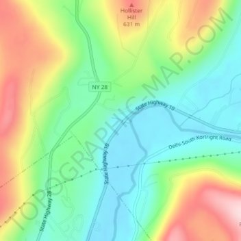
Naam: Topografische kaart Falls Creek, hoogte, reliëf.
Gemiddelde hoogte: 515 m
Minimale hoogte: 414 m
Maximale hoogte: 686 m
Andere topografische kaarten
Klik op een kaart om zijn topografie, zijn hoogte en zijn reliëf te bekijken.
Graham
USA > New York > Town of Mount Pleasant > Graham
Graham, Town of Mount Pleasant, Westchester County, New York, 10532, USA
Gemiddelde hoogte: 111 m
Flat Top Mountain
Flat Top Mountain, Franklin County, New York, USA
Gemiddelde hoogte: 568 m
Livingston Island
Livingston Island, Town of Philipstown, Putnam County, New York, 10922, USA
Gemiddelde hoogte: 156 m
Avalanche Lake
Avalanche Lake, Avalanche Pass Trail, Essex County, New York, USA
Gemiddelde hoogte: 1.066 m
Roosevelt Island
USA > New York > New York City
Roosevelt Island, Manhattan Community Board 8, New York County, New York City, New York, 10044, USA
Gemiddelde hoogte: 13 m
Midtown South
USA > New York > New York City
Midtown South, Manhattan, Manhattan Community Board 5, New York County, New York City, New York, 10118, USA
Gemiddelde hoogte: 20 m
Farmingville
USA > New York > Farmingville
Farmingville, Suffolk County, New York, 11738, USA
Gemiddelde hoogte: 47 m