
Topografische kaart Keriézou
Interactieve kaart
Klik op de kaart om de hoogte weer te geven.
Over deze kaart
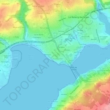
Naam: Topografische kaart Keriézou, hoogte, reliëf.
Gemiddelde hoogte: 30 m
Minimale hoogte: -2 m
Maximale hoogte: 116 m
Andere topografische kaarten
Klik op een kaart om zijn topografie, zijn hoogte en zijn reliëf te bekijken.
Keroumen
France > Bretagne > Finistère > Le Relecq-Kerhuon
Keroumen, Le Relecq-Kerhuon, Brest, Finistère, Bretagne, France métropolitaine, 29480, France
Gemiddelde hoogte: 51 m
Poul ar Feunteun
France > Bretagne > Finistère > Le Relecq-Kerhuon
Poul ar Feunteun, Le Relecq-Kerhuon, Brest, Finistère, Bretagne, France métropolitaine, 29480, France
Gemiddelde hoogte: 49 m
Kergaret
France > Bretagne > Finistère > Le Relecq-Kerhuon
Kergaret, Le Relecq-Kerhuon, Brest, Finistère, Bretagne, France métropolitaine, 29480, France
Gemiddelde hoogte: 43 m
Baradozic
France > Bretagne > Finistère > Le Relecq-Kerhuon
Baradozic, Le Relecq-Kerhuon, Brest, Finistère, Bretagne, France métropolitaine, 29480, France
Gemiddelde hoogte: 29 m
Feunteun Aon
France > Bretagne > Finistère > Le Relecq-Kerhuon > Feunteun Aon
Feunteun Aon, Le Relecq-Kerhuon, Brest, Finistère, Bretagne, France métropolitaine, 29480, France
Gemiddelde hoogte: 29 m
Le Cosquer
France > Bretagne > Finistère > Le Relecq-Kerhuon
Le Cosquer, Le Relecq-Kerhuon, Brest, Finistère, Bretagne, France métropolitaine, 29480, France
Gemiddelde hoogte: 39 m
Rubian
France > Bretagne > Finistère > Le Relecq-Kerhuon
Rubian, Le Relecq-Kerhuon, Brest, Finistère, Bretagne, France métropolitaine, 29480, France
Gemiddelde hoogte: 33 m