
Topografische kaart Mount Wellington
Interactieve kaart
Klik op de kaart om de hoogte weer te geven.
Over deze kaart
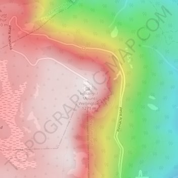
Naam: Topografische kaart Mount Wellington, hoogte, reliëf.
Locatie: Mount Wellington, City of Hobart, Tasmania, Australia (-42.89606 147.23726 -42.89596 147.23736)
Gemiddelde hoogte: 941 m
Minimale hoogte: 443 m
Maximale hoogte: 1.263 m
"... In many parts the Eucalypti grew to a great size, and composed a noble forest. In some of the dampest ravines, tree-ferns flourished in an extraordinary manner; I saw one which must have been at least twenty feet high to the base of the fronds, and was in girth exactly six feet. The fronds forming the most elegant parasols, produced a gloomy shade, like that of the first hour of the night. The summit of the mountain is broad and flat, and is composed of huge angular masses of naked greenstone. Its elevation is 3,100 feet [940 m] above the level of the sea. The day was splendidly clear, and we enjoyed a most extensive view; to the north, the country appeared a mass of wooded mountains, of about the same height with that on which we were standing, and with an equally tame outline: to the south the broken land and water, forming many intricate bays, was mapped with clearness before us. ..."
Andere topografische kaarten
Klik op een kaart om zijn topografie, zijn hoogte en zijn reliëf te bekijken.
Launceston
Australia > Tasmania > Launceston
Launceston, Tasmania, 7250, Australia
Gemiddelde hoogte: 218 m
Cradle Mountain
Australia > Tasmania > Cradle Mountain
Cradle Mountain, Cradle Mount Summit Track, Cradle Mountain, Meander Valley, Tasmania, Australia
Gemiddelde hoogte: 1.144 m
West Kentish
West Kentish, Kentish, Tasmania, 7306, Australia
Gemiddelde hoogte: 291 m
Mount Lloyd
Mount Lloyd, Derwent Valley, Tasmania, 7140, Australia
Gemiddelde hoogte: 558 m
West Ulverstone
Australia > Tasmania > Ulverstone
West Ulverstone, Ulverstone, Central Coast, Tasmania, 7315, Australia
Gemiddelde hoogte: 26 m
Connellys Marsh
Connellys Marsh, Sorell, Tasmania, 7173, Australia
Gemiddelde hoogte: 41 m
Mount Direction
Mount Direction, Hobart, City of Clarence, Tasmania, 7017, Australia
Gemiddelde hoogte: 166 m
Styx River
Australia > Tasmania > Westerway
Styx River, Westerway, Derwent Valley, Tasmania, Australia
Gemiddelde hoogte: 548 m
West Montagu
West Montagu, Circular Head, Tasmania, 7330, Australia
Gemiddelde hoogte: 35 m
Bruny Island
Australia > Tasmania > Alonnah
Bruny Island, Alonnah, Kingborough, Tasmania, Australia
Gemiddelde hoogte: 59 m
Arthurs Lake
Arthurs Lake, Central Highlands, Tasmania, 7030, Australia
Gemiddelde hoogte: 910 m
Garden Island Creek
Garden Island Creek, Huon Valley, Tasmania, 7112, Australia
Gemiddelde hoogte: 153 m
Lower Turners Marsh
Lower Turners Marsh, City of Launceston, Tasmania, 7267, Australia
Gemiddelde hoogte: 141 m
Lower Longley
Lower Longley, Hobart, Kingborough, Tasmania, 7109, Australia
Gemiddelde hoogte: 338 m
Launceston
Launceston, City of Launceston, Tasmania, Australia
Gemiddelde hoogte: 194 m
Greens Beach
Greens Beach, West Tamar, Tasmania, 7270, Australia
Gemiddelde hoogte: 30 m
Launceston
Launceston, City of Launceston, Tasmania, 7250, Australia
Gemiddelde hoogte: 26 m
Claude Road
Claude Road, Kentish, Tasmania, 7306, Australia
Gemiddelde hoogte: 444 m
Black Hills
Black Hills, Derwent Valley, Tasmania, 7140, Australia
Gemiddelde hoogte: 432 m
Chain Of Lagoons
Chain Of Lagoons, Break O'Day, Tasmania, 7215, Australia
Gemiddelde hoogte: 154 m
Deddington
Deddington, Northern Midlands, Tasmania, 7212, Australia
Gemiddelde hoogte: 358 m
Selfs Point
Selfs Point, New Town, Hobart, City of Hobart, Tasmania, 7008, Australia
Gemiddelde hoogte: 17 m
Lake Murchison
Australia > Tasmania > Tullah > Lake St Clair
Lake Murchison, Lake St Clair, Tullah, West Coast, Tasmania, Australia
Gemiddelde hoogte: 531 m
Lower Barrington
Lower Barrington, Kentish, Tasmania, 7306, Australia
Gemiddelde hoogte: 202 m
Barrington
Barrington, Kentish, Tasmania, 7306, Australia
Gemiddelde hoogte: 228 m
Nowhere Else
Nowhere Else, Kentish, Tasmania, 7306, Australia
Gemiddelde hoogte: 279 m