
Topografische kaart Żywiec
Interactieve kaart
Klik op de kaart om de hoogte weer te geven.
Over deze kaart
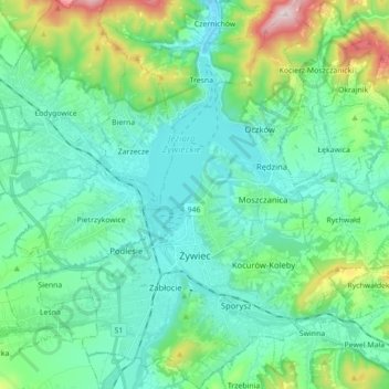
Naam: Topografische kaart Żywiec, hoogte, reliëf.
Locatie: Żywiec, Żywiec County, Silesian Voivodeship, 34-300, Poland (49.64987 19.15181 49.76312 19.26800)
Gemiddelde hoogte: 431 m
Minimale hoogte: 319 m
Maximale hoogte: 857 m
Andere topografische kaarten
Klik op een kaart om zijn topografie, zijn hoogte en zijn reliëf te bekijken.
Majdany
Poland > Silesian Voivodeship > Żywiec County > Rychwałd
Majdany, Rychwałd, gmina Gilowice, Żywiec County, Silesian Voivodeship, 34-321, Poland
Gemiddelde hoogte: 401 m
Wieczorek
Poland > Silesian Voivodeship > Żywiec County > Zwardoń
Wieczorek, Zwardoń, gmina Rajcza, Żywiec County, Silesian Voivodeship, 34-373, Poland
Gemiddelde hoogte: 720 m
Koszarawa
Poland > Silesian Voivodeship > Żywiec County
Koszarawa, gmina Koszarawa, Żywiec County, Silesian Voivodeship, 34-332, Poland
Gemiddelde hoogte: 678 m
Żywiec
Poland > Silesian Voivodeship > Żywiec County > Żywiec
Żywiec, Żywiec County, Silesian Voivodeship, Poland
Gemiddelde hoogte: 437 m