
Topografische kaart Little Heffley Lake
Interactieve kaart
Klik op de kaart om de hoogte weer te geven.
Over deze kaart
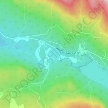
Naam: Topografische kaart Little Heffley Lake, hoogte, reliëf.
Gemiddelde hoogte: 1.035 m
Minimale hoogte: 910 m
Maximale hoogte: 1.298 m
Andere topografische kaarten
Klik op een kaart om zijn topografie, zijn hoogte en zijn reliëf te bekijken.
Badger Lake
Canada > British Columbia > Thompson-Nicola Regional District > Area P (Rivers and the Peaks)
Badger Lake, Area P (Rivers and the Peaks), Thompson-Nicola Regional District, British Columbia, Canada
Gemiddelde hoogte: 1.157 m
Knouff Lake
Canada > British Columbia > Thompson-Nicola Regional District > Area P (Rivers and the Peaks)
Knouff Lake, Area P (Rivers and the Peaks), Thompson-Nicola Regional District, British Columbia, Canada
Gemiddelde hoogte: 1.249 m
Mount Knouff
Canada > British Columbia > Thompson-Nicola Regional District > Area P (Rivers and the Peaks)
Mount Knouff, Area P (Rivers and the Peaks), Thompson-Nicola Regional District, British Columbia, Canada
Gemiddelde hoogte: 1.225 m
Pritchard
Canada > British Columbia > Thompson-Nicola Regional District > Area P (Rivers and the Peaks)
Pritchard, Area P (Rivers and the Peaks), Thompson-Nicola Regional District, British Columbia, V0E 2P0, Canada
Gemiddelde hoogte: 433 m
Paul Lake
Canada > British Columbia > Thompson-Nicola Regional District > Area P (Rivers and the Peaks)
Paul Lake, Area P (Rivers and the Peaks), Thompson-Nicola Regional District, British Columbia, Canada
Gemiddelde hoogte: 926 m
Niskonlith Lake
Canada > British Columbia > Thompson-Nicola Regional District > Area P (Rivers and the Peaks)
Niskonlith Lake, Area P (Rivers and the Peaks), Thompson-Nicola Regional District, British Columbia, Canada
Gemiddelde hoogte: 601 m