
Topografische kaart Plamondon
Interactieve kaart
Klik op de kaart om de hoogte weer te geven.
Over deze kaart
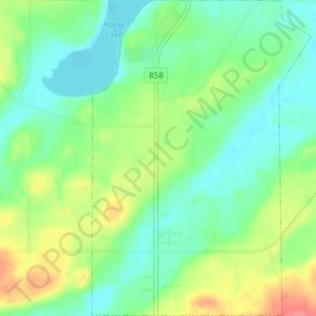
Naam: Topografische kaart Plamondon, hoogte, reliëf.
Locatie: Plamondon, Lac La Biche County, Alberta, T0A 2T0, Canada (54.84186 -112.35730 54.87828 -112.31327)
Gemiddelde hoogte: 562 m
Minimale hoogte: 541 m
Maximale hoogte: 602 m
Andere topografische kaarten
Klik op een kaart om zijn topografie, zijn hoogte en zijn reliëf te bekijken.
Hamlet of Lac la Biche
Canada > Alberta > Lac La Biche County
Hamlet of Lac la Biche, Lac La Biche County, Alberta, Canada
Gemiddelde hoogte: 550 m
Lac La Biche
Canada > Alberta > Lac La Biche County > Hamlet of Lac la Biche
Lac La Biche, Hamlet of Lac la Biche, Lac La Biche County, Alberta, Canada
Gemiddelde hoogte: 563 m