
Topografische kaart Gorlice
Interactieve kaart
Klik op de kaart om de hoogte weer te geven.
Gorlice
The city lies between the Ropa and Sękówka river valleys, surrounded by several mountain ranges of the Carpathian Mountains, namely their part called Beskid Niski (Low Beskids) massive. It is located in the heartland of the Doły (Pits), and its average elevation above sea level is 380 metres (1,247 feet), although there are some more considerable hills located within the confines of the city. The city is nowadays situated in a heavily populated region 14.6 miles (23.5 kilometres) from Jasło, 21.2 mi (34.1 km) from Nowy Sącz, 25.5 mi (41.0 km) from Tarnów, and 62.6 mi (100.7 km) from Kraków. Gorlice is known in Ukrainian: as Horlytsi, Горлиці; in Yiddish: גאָרליץ as Gorlitz; and in German: as Görlitz.
Over deze kaart
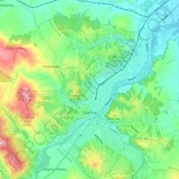
Naam: Topografische kaart Gorlice, hoogte, reliëf.
Locatie: Gorlice, Gorlice County, Lesser Poland Voivodeship, Poland (49.63483 21.11896 49.69780 21.21293)
Gemiddelde hoogte: 315 m
Minimale hoogte: 264 m
Maximale hoogte: 435 m
Andere topografische kaarten
Klik op een kaart om zijn topografie, zijn hoogte en zijn reliëf te bekijken.