
Topografische kaart El Jobo
Interactieve kaart
Klik op de kaart om de hoogte weer te geven.
Over deze kaart
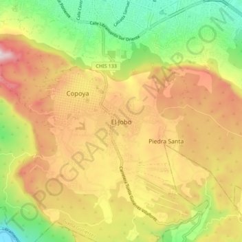
Naam: Topografische kaart El Jobo, hoogte, reliëf.
Locatie: El Jobo, Tuxtla Gutiérrez, Chiapas, 29066, México (16.66227 -93.14433 16.74227 -93.06433)
Gemiddelde hoogte: 791 m
Minimale hoogte: 445 m
Maximale hoogte: 1.148 m
Andere topografische kaarten
Klik op een kaart om zijn topografie, zijn hoogte en zijn reliëf te bekijken.
Tuxtla Gutiérrez
México > Chiapas > Tuxtla Gutiérrez
Tuxtla Gutiérrez, Chiapas, 29019, México
Gemiddelde hoogte: 817 m
Parque Bicentenario
México > Chiapas > Tuxtla Gutiérrez > Tuxtla Gutiérrez
Parque Bicentenario, Tuxtla Gutiérrez, Chiapas, México
Gemiddelde hoogte: 554 m
Cañón del Sumidero
México > Chiapas > Tuxtla Gutiérrez > Tuxtla Gutiérrez
Cañón del Sumidero, Tuxtla Gutiérrez, Chiapas, México
Gemiddelde hoogte: 1.097 m
Malibu
México > Chiapas > Tuxtla Gutiérrez > Terán
Malibu, Terán, Tuxtla Gutiérrez, Chiapas, 29020, México
Gemiddelde hoogte: 645 m
Copoya
México > Chiapas > Tuxtla Gutiérrez
Copoya, Tuxtla Gutiérrez, Chiapas, 29066, México
Gemiddelde hoogte: 753 m
Terán
México > Chiapas > Tuxtla Gutiérrez
Terán, Tuxtla Gutiérrez, Chiapas, 29020, México
Gemiddelde hoogte: 667 m