
Topografische kaart Mount Brandon
Interactieve kaart
Klik op de kaart om de hoogte weer te geven.
Over deze kaart
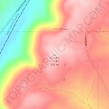
Naam: Topografische kaart Mount Brandon, hoogte, reliëf.
Locatie: Mount Brandon, DeKalb County, Alabama, United States (34.38504 -85.75335 34.38514 -85.75325)
Gemiddelde hoogte: 419 m
Minimale hoogte: 248 m
Maximale hoogte: 509 m
Andere topografische kaarten
Klik op een kaart om zijn topografie, zijn hoogte en zijn reliëf te bekijken.
Fort Payne
United States > Alabama > DeKalb County
Fort Payne, DeKalb County, Alabama, 35967, United States
Gemiddelde hoogte: 369 m
Pine Ridge
United States > Alabama > DeKalb County
Pine Ridge, DeKalb County, Alabama, United States
Gemiddelde hoogte: 312 m
Wooten Hill
United States > Alabama > DeKalb County
Wooten Hill, DeKalb County, Alabama, United States
Gemiddelde hoogte: 387 m
Mentone
United States > Alabama > DeKalb County > Mentone
Mentone, DeKalb County, Alabama, 35984, United States
Gemiddelde hoogte: 470 m
Shiloh
United States > Alabama > DeKalb County > Shiloh
Shiloh, DeKalb County, Alabama, United States
Gemiddelde hoogte: 378 m