
Topografische kaart Olivos
Interactieve kaart
Klik op de kaart om de hoogte weer te geven.
Over deze kaart
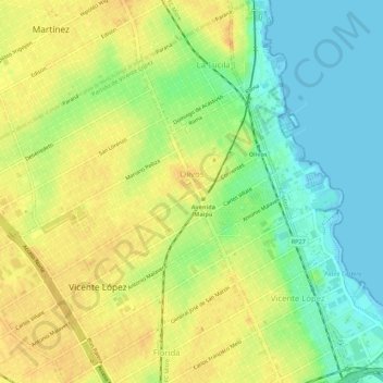
Naam: Topografische kaart Olivos, hoogte, reliëf.
Gemiddelde hoogte: 17 m
Minimale hoogte: -2 m
Maximale hoogte: 31 m
Olivos is located on the western bank of the Río de la Plata, the world's widest river. The river is approximately 50 km (31 mi) wide at Olivos, and as such, Uruguay is not visible from ground level. However, Olivos (and this entire region of the Rio) do not have sandy beaches; the shoreline is relatively rocky. Comparable shorelines include those of the Great Lakes in North America. The city's topography is relatively flat. However, there are some ridges by the river towards the north, in the La Lucila neighbourhood.
Andere topografische kaarten
Klik op een kaart om zijn topografie, zijn hoogte en zijn reliëf te bekijken.
Munro
Argentina > Buenos Aires > Vicente López
Munro, Vicente López, Partido de Vicente López, Buenos Aires, Argentina
Gemiddelde hoogte: 26 m
Vicente López
Argentina > Buenos Aires > Vicente López
Vicente López, Partido de Vicente López, Buenos Aires, Argentina
Gemiddelde hoogte: 20 m