
Topografische kaart Santo Antonino
Interactieve kaart
Klik op de kaart om de hoogte weer te geven.
Over deze kaart
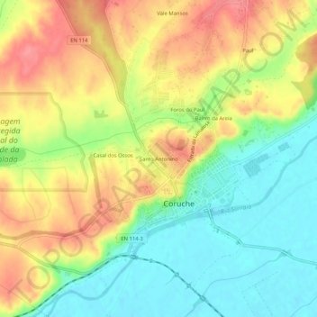
Naam: Topografische kaart Santo Antonino, hoogte, reliëf.
Gemiddelde hoogte: 48 m
Minimale hoogte: 11 m
Maximale hoogte: 88 m
Andere topografische kaarten
Klik op een kaart om zijn topografie, zijn hoogte en zijn reliëf te bekijken.
Ovelhas
Portugal > Santarém > Coruche > São José da Lamarosa
Ovelhas, São José da Lamarosa, Coruche, Santarém, Portugal
Gemiddelde hoogte: 86 m
Malhada Alta
Malhada Alta, Coruche, Fajarda e Erra, Coruche, Santarém, Portugal
Gemiddelde hoogte: 66 m
Volta do Vale
Volta do Vale, Couço, Coruche, Santarém, Portugal
Gemiddelde hoogte: 56 m
Santana do Mato
Portugal > Santarém > Coruche > Santana do Mato
Santana do Mato, Coruche, Santarém, Portugal
Gemiddelde hoogte: 106 m