
Topografische kaart Anini
Interactieve kaart
Klik op de kaart om de hoogte weer te geven.
Over deze kaart
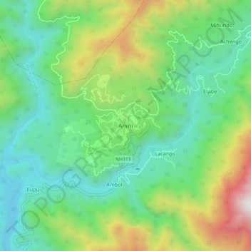
Naam: Topografische kaart Anini, hoogte, reliëf.
Gemiddelde hoogte: 1.660 m
Minimale hoogte: 1.079 m
Maximale hoogte: 3.029 m
The small settlement of Anini is located at an elevation of 1,968 metres (6,457 ft) above sea level. On the Aninese Plateau, the average elevation is 1,800 meters, but the average elevation of the town is 2,068 meters. According to Google Maps' terrain feature, Anini is around 1,600–1,800 meters above sea level and up north of Anini, the elevation can go up to 3,800 meters above sea level. According to the official website of the Dibang Valley District, Anini's altitude is at 1,968 meters above sea level.
Andere topografische kaarten
Klik op een kaart om zijn topografie, zijn hoogte en zijn reliëf te bekijken.
Bruini
India > Arunachal Pradesh > Anini Circle
Bruini, Anini Circle, Dibang Valley District, Arunachal Pradesh, India
Gemiddelde hoogte: 3.057 m