
Topografische kaart Oingo Lake
Interactieve kaart
Klik op de kaart om de hoogte weer te geven.
Over deze kaart
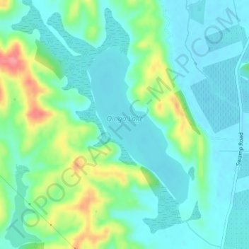
Naam: Topografische kaart Oingo Lake, hoogte, reliëf.
Gemiddelde hoogte: 38 m
Minimale hoogte: 15 m
Maximale hoogte: 103 m
Andere topografische kaarten
Klik op een kaart om zijn topografie, zijn hoogte en zijn reliëf te bekijken.
Runanga Lake
Runanga Lake, Ohiti Road, Omahu, Hastings District, Hawke's Bay, 4175, New Zealand
Gemiddelde hoogte: 73 m
Te Roto Kare
Te Roto Kare, State Highway 50, Kingsley Chatham, Omahu, Hastings District, Hawke's Bay, 4175, New Zealand
Gemiddelde hoogte: 37 m