
Doe een donatie
Rust jezelf uit voor je volgende avontuur:
Als Amazon-partner verdient deze site een commissie op in aanmerking komende aankopen, zonder extra kosten voor jou.
Topografische kaart Taza
Klik op de kaart om de hoogte weer te geven.
Doe een donatie
Rust jezelf uit voor je volgende avontuur:
Als Amazon-partner verdient deze site een commissie op in aanmerking komende aankopen, zonder extra kosten voor jou.
Taza
Taza is located in north-central Morocco, in the south of the Rif region right outside the mountain range on a narrow plain. The city is composed of two formerly separate towns built on separate terraces overlooking a mountain valley. The old-Taza town is at an elevation of 1,919 feet (585 m) above sea level and is surrounded by fortifications; the newer town, established by the French in 1920, is located in a fertile plain at an elevation of 1,460 feet (445 m). Fossil remains indicate that caves in the area were inhabited as early as the Paleolithic Period. One of the most important caves in Morocco, Rhar Chara, is close to Taza. This cave is over 7.6 kilometres long.
Doe een donatie
Rust jezelf uit voor je volgende avontuur:
Als Amazon-partner verdient deze site een commissie op in aanmerking komende aankopen, zonder extra kosten voor jou.
Over deze kaart
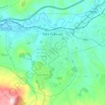
Naam: Topografische kaart Taza, hoogte, reliëf.
Gemiddelde hoogte: 536 m
Minimale hoogte: 409 m
Maximale hoogte: 990 m
Doe een donatie
Rust jezelf uit voor je volgende avontuur:
Als Amazon-partner verdient deze site een commissie op in aanmerking komende aankopen, zonder extra kosten voor jou.