
Topografische kaart South End
Interactieve kaart
Klik op de kaart om de hoogte weer te geven.
Over deze kaart
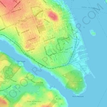
Naam: Topografische kaart South End, hoogte, reliëf.
Gemiddelde hoogte: 23 m
Minimale hoogte: -1 m
Maximale hoogte: 72 m
Andere topografische kaarten
Klik op een kaart om zijn topografie, zijn hoogte en zijn reliëf te bekijken.
Second Chain Lake
Canada > Nouvelle-Écosse > Halifax
Second Chain Lake, St Margarets Bay Road, Armdale, Halifax, Halifax Regional Municipality, Halifax County, Nouvelle-Écosse, B3N 2A1, Canada
Gemiddelde hoogte: 87 m
Colpitt Lake
Canada > Nouvelle-Écosse > Halifax
Colpitt Lake, Alabaster Way, Governor's Brook, Spryfield, Halifax, Halifax Regional Municipality, Halifax County, Nouvelle-Écosse, B3P 1M2, Canada
Gemiddelde hoogte: 47 m