
Topografische kaart Siegen
Interactieve kaart
Klik op de kaart om de hoogte weer te geven.
Over deze kaart
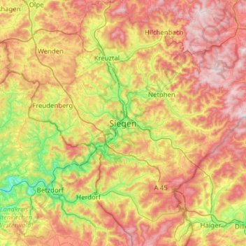
Naam: Topografische kaart Siegen, hoogte, reliëf.
Gemiddelde hoogte: 401 m
Minimale hoogte: 149 m
Maximale hoogte: 686 m
The city's total land area is roughly 115 km2 (44 sq mi). Its greatest east-west span is about 12 km (7 mi), and its greatest north-south span is about 12 km (7 mi). City limits are 48 km (30 mi) long. Siegen lies at a median elevation of 290 m (951 ft) above sea level. The city's greatest elevation is the peak of the Pfannenberg at 499 m (1,637 ft) above sea level at southern city limits. Siegen's lowest point is 215 m (705 ft) above sea level at Niederschelden at southwestern city limits, which there also forms the state boundary with Rhineland-Palatinate. Roughly 60% of the city's land is wooded, making Siegen one of Germany's greenest cities.